Pecos Valley Aquiferinteractive map | cross-section
Aquifer Facts
- Aquifer type: unconfined
- Area of aquifer: 6,829 square miles
- Proportion of aquifer with groundwater conservation districts: 47 percent
- Number of counties containing the aquifer: 12
Summary
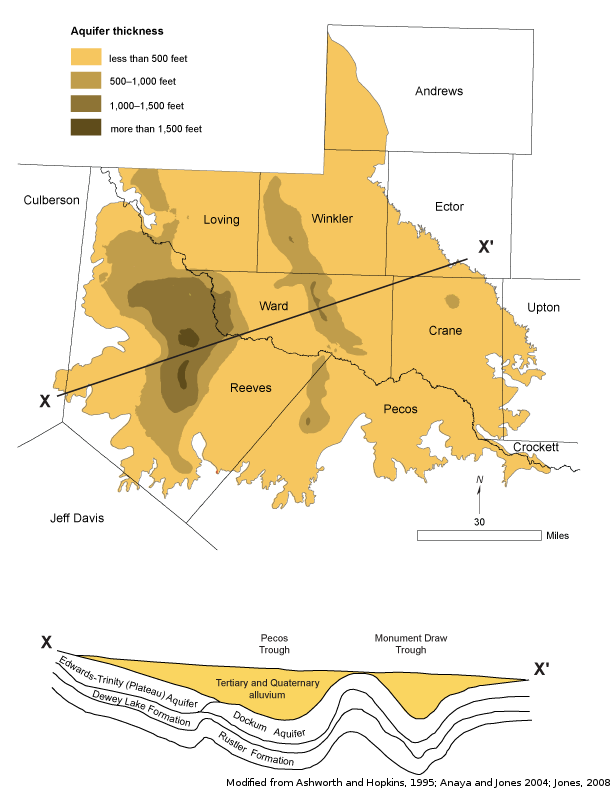
The Pecos Valley Aquifer is a major aquifer in West Texas. Water-bearing sediments include alluvial and windblown deposits in the Pecos River Valley. These sediments fill several structural basins, the largest of which are the Pecos Trough in the west and Monument Draw Trough in the east. Thickness of the alluvial fill reaches 1,500 feet, and freshwater saturated thickness averages about 250 feet.
The water quality is highly variable, the water being typically hard, and generally better in the Monument Draw Trough than in the Pecos Trough. Total dissolved solids in groundwater from Monument Draw Trough are usually less than 1,000 milligrams per liter. The aquifer is characterized by high levels of chloride and sulfate in excess of secondary drinking water standards, resulting from previous oil field activities. In addition, naturally occurring arsenic and radionuclides occur in excess of primary drinking water standards.
More than 80 percent of groundwater pumped from the aquifer is used for irrigation, and the rest is withdrawn for municipal supplies, industrial use, and power generation. Localized water levels have rebounded in the south-central Reeves and northwest Pecos counties since the late 1970s as irrigation pumping has decreased. However, water levels continue to decline in central Ward County because of increased municipal and industrial pumping.
Reports
| ID | Date | Type | Description |
|---|---|---|---|
| Texas Aquifers Study | 12/31/2016 | Legislative Report | Texas Aquifers Study: Groundwater Quantity, Quality, Flow, and Contributions to Surface Water |
| HA-03 | 1/1/1995 | Hydrologic atlas | Water Quality in the Edwards-Trinity (Plateau) Aquifer, Edwards Plateau and Trans-Pecos, Texas |
| R-317 | 1/1/1990 | TWDB numbered report | Evaluation of Ground-Water Resources in Parts of Loving, Pecos, Reeves, Ward and Winkler Counties, Texas |
| R-348 | 11/1/1999 | TWDB numbered report | Changes in Groundwater Conditions in Parts of Trans-Pecos, Texas, 1988 - 1998 |
| R-356 | 12/1/2001 | TWDB numbered report | Aquifers of West Texas |
| B-5604 | 3/1/1956 | Groundwater bulletin | Ground-Water Resources of the Crane Sandhills, Crane County, Texas |
| R-360 | 2/9/2004 | TWDB numbered report | Conference Proceedings: Aquifers of the Edwards Plateau |
| R-078 | 5/1/1968 | TWDB numbered report | Ground-Water Resources of Upton County, Texas |
| GT10-033 | 1/3/2011 | GAM task | Average drawdown for the Edwards-Trinity (Plateau) and Pecos Valley aquifers within management zones in Middle Pecos GCD |
| GR09-035_D | 8/7/2010 | GAM run | Predictive simulations for the Edwards-Trinity (Plateau) and Pecos Valley aquifers in Groundwater Management Area 7 |
| GR08-075_MP | 1/23/2009 | GAM run - Management Plan | Management plan information for Middle Pecos GCD |
| GR08-027_MP | 5/21/2008 | GAM run - Management Plan | Management plan information for Crockett County GCD |
| GR04-020 | 10/7/2004 | GAM run | Effects of a new well field in Middle Pecos GCD |
| GR12-004_MP | 7/20/2012 | GAM run - Management Plan | Management plan data for Crockett County GCD |
| GR12-023_MP | 8/10/2012 | GAM run - Management Plan | Management plan data for Jeff Davis County UWCD |
| R-380 | 7/1/2011 | TWDB numbered report | Aquifers of Texas |
| CR-0904830820 | 4/1/2010 | Contract report | Application of PEST to Re-Calibrate the Groundwater Availability Model for the Edwards-Trinity (Plateau) and Pecos Valley Aquifers |
| GT13-026_TERS | 9/19/2013 | GAM task - Total Estimated Recoverable Storage | Total Estimated Recoverable Storage for aquifers in Groundwater Management Area 2 |
| GT13-027_TERS | 9/19/2013 | GAM task - Total Estimated Recoverable Storage | Total Estimated Recoverable Storage for aquifers in Groundwater Management Area 3 |
| GT13-030_TERS | 10/2/2013 | GAM task - Total Estimated Recoverable Storage | Total Estimated Recoverable Storage for aquifers in Groundwater Management Area 7 |
| GT13-028_TERS | 1/15/2014 | GAM task - Total Estimated Recoverable Storage | Total Estimated Recoverable Storage for aquifers in Groundwater Management Area 4 |
| GR14-010_MP | 3/26/2014 | GAM run - Management Plan | Management Plan data for Middle Pecos GCD |
| GR17-022_MP | 3/28/2017 | GAM run - Management Plan | Management plan information for Crockett County GCD |
| GR18-001_MP | 5/10/2018 | GAM run - Management Plan | Management plan information for Reeves County GCD |
| GR19-021_MP | 2/20/2020 | GAM run - Management Plan | Management plan information for Middle Pecos GCD |
| GR23-001_MP | 5/10/2023 | GAM run - Management Plan | Management plan information for Reeves County GCD |
| GR23-010_MP | 06/07/2023 | GAM run - Management Plan | Management plan information for Jeff Davis County UWCD |
| GR23-006_MP | 08/23/2023 | GAM run - Management Plan | Management plan information for Crockett County GCD |